Wedderburn, Oregon | |
|---|---|
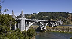
 Wedderburn can be seen from across the Isaac Lee Patterson Bridge. | |
| Coordinates: 42°25′47″N 124°24′50″W / 42.42972°N 124.41389°W | |
| Country | United States |
| State | Oregon |
| County | Curry |
| Area | |
• Total | 1.26 sq mi (3.26 km2) |
| • Land | 1.06 sq mi (2.74 km2) |
| • Water | 0.20 sq mi (0.52 km2) |
| Elevation | 39 ft (12 m) |
| Population | |
• Total | 426 |
| • Density | 403.03/sq mi (155.62/km2) |
| Time zone | UTC-8 (Pacific (PST)) |
| • Summer (DST) | UTC-7 (PDT) |
| ZIP code | 97444[4] |
| Area code(s) | 458 and 541 |
| FIPS code | 41-79500 |
| GNIS feature ID | 1151991[2] |
Wedderburn is an unincorporated coastal community in Curry County, Oregon, United States. It is to the north of, and across the mouth of the Rogue River from Gold Beach, on U.S. Route 101. The Isaac Lee Patterson Bridge connects Wedderburn with Gold Beach.
- ^ "ArcGIS REST Services Directory". United States Census Bureau. Retrieved October 12, 2022.
- ^ a b U.S. Geological Survey Geographic Names Information System: Wedderburn, Oregon
- ^ Cite error: The named reference
USCensusDecennial2020CenPopScriptOnlywas invoked but never defined (see the help page). - ^ "Wedderburn OR ZIP Code". zipdatamaps.com. 2023. Retrieved June 16, 2023.

