Welbourn | |
|---|---|
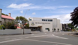
 New Plymouth Boys' High School | |
 | |
| Coordinates: 39°4′10″S 174°5′31″E / 39.06944°S 174.09194°E | |
| Country | New Zealand |
| City | New Plymouth |
| Local authority | New Plymouth District Council |
| Electoral ward |
|
| Area | |
| • Land | 687 ha (1,698 acres) |
| Population (June 2024)[2] | |
• Total | 3,640 |
| New Plymouth Central | Strandon | Merrilands |
| Brooklands |
|
|
| Brooklands | Highlands Park |
Welbourn (often misspelled Welbourne) is a suburb of New Plymouth, in the western North Island of New Zealand. It is located to the southeast of the city centre. Te Henui Stream runs through the suburb and State Highway 3 forms its western boundary.[3]
The suburb began as a railway settlement.[4]
- ^ Cite error: The named reference
Areawas invoked but never defined (see the help page). - ^ "Aotearoa Data Explorer". Statistics New Zealand. Retrieved 26 October 2024.
- ^ North Island Provincial Town Maps (5th ed.). Wises Maps. pp. 91, 93.
- ^ Murdoch, Janet (2007). "The Railway Leads to Welbourn" (PDF).