| Wentworth New South Wales | |||||||||
|---|---|---|---|---|---|---|---|---|---|
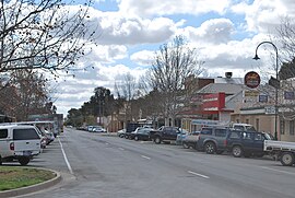
 Darling Street, Wentworth | |||||||||
| Coordinates | 34°05′0″S 141°54′0″E / 34.08333°S 141.90000°E | ||||||||
| Population | 1,221 (2016 census)[1] | ||||||||
| Postcode(s) | 2648 | ||||||||
| Elevation | 37.0 m (121 ft) | ||||||||
| Location | 1,034 km (642 mi) from Sydney | ||||||||
| LGA(s) | Wentworth Shire | ||||||||
| State electorate(s) | Murray | ||||||||
| Federal division(s) | Farrer | ||||||||
| |||||||||
Wentworth is a small border town in the far south west of the state of New South Wales, Australia. It lies at the confluence of Australia's two most important rivers, the Darling and the Murray, the latter forming the border with the state of Victoria to the south. The border with the state of South Australia lies approximately 100 kilometres (62 mi) to the west. The town of Wentworth is in the local government area of the same name.
- ^ "2011 Census Quickstats". Australian Bureau of Statistics. Retrieved 22 June 2012.
