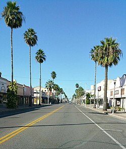
Weslaco, Texas | |
|---|---|
 | |
 | |
| Coordinates: 26°9′33″N 97°59′15″W / 26.15917°N 97.98750°W | |
| Country | United States |
| State | Texas |
| County | Hidalgo |
| Government | |
| • Type | Council-Manager |
| • City Council | Mayor Adrian Gonzalez Gregory P. Kerr Leo Munoz Leticia "Letty" Lopez Jose "JP" Rodriguez Josh Pedraza Adrian Farias |
| • City Manager | Martin Garza |
| Area | |
• Total | 16.45 sq mi (42.61 km2) |
| • Land | 16.38 sq mi (42.42 km2) |
| • Water | 0.07 sq mi (0.19 km2) |
| Elevation | 79 ft (24 m) |
| Population (2020) | |
• Total | 40,160 |
| • Density | 2,400/sq mi (940/km2) |
| Time zone | UTC-6 (Central (CST)) |
| • Summer (DST) | UTC-5 (CDT) |
| ZIP Codes | 78596, 78599 |
| Area code | 956 |
| FIPS code | 48-77272[2] |
| GNIS feature ID | 1349656[3] |
| Website | www |
Weslaco (/ˈwɛsləkoʊ/ WESS-lə-koh) is a city in Hidalgo County, Texas, United States. As of the 2020 census the population was 41,103, Studies from 2023 show the population is 43,053 [4] and in 2020 the estimated population was 40,160.[5] It is located at the southern tip of Texas in the Rio Grande Valley near the Mexican border, across the Rio Grande from the city of Nuevo Progreso, Rio Bravo, Tamaulipas.
Weslaco derives its name from the W.E. Stewart Land Company.[6] It was the hometown of Harlon Block, one of the Marines photographed raising the flag at Iwo Jima, and of film and television actor David Spielberg.
Streets north of the railroad tracks have Spanish names, and streets south of the railroad tracks bear names in English, as a consequence of a 1921 municipal ordinance which declared that land north of the tracks be reserved for Hispanic residences and businesses, and land south of the tracks be reserved for "Anglo" residences and businesses. During World War II, sandbag production reached a peak in Weslaco, and the town declared itself the "sandbagging capital of the world".
Weslaco is part of the McAllen–Edinburg–Mission and Reynosa–McAllen metropolitan areas.
- ^ "2019 U.S. Gazetteer Files". United States Census Bureau. Retrieved August 7, 2020.
- ^ "U.S. Census website". United States Census Bureau. Retrieved January 31, 2008.
- ^ "US Board on Geographic Names". United States Geological Survey. October 25, 2007. Retrieved January 31, 2008.
- ^ "Geographic Identifiers: 2020 Census Summary File 1 (G001): Weslaco city, Texas". American Factfinder. U.S. Census Bureau. Archived from the original on February 13, 2020. Retrieved February 21, 2018.
- ^ "Population and Housing Unit Estimates". Retrieved May 21, 2020.
- ^ Temple, Robert D. Edge Effects: The Border-Name Places, (2nd edition, 2009), iUniverse, ISBN 978-0-595-47758-6, page 324.