West Carrollton, Ohio | |
|---|---|
 Aerial view of West Carrollton/ Miamisburg | |
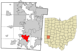
 Location in Montgomery County and the state of Ohio. | |
| Coordinates: 39°40′05″N 84°14′50″W / 39.66806°N 84.24722°W | |
| Country | United States |
| State | Ohio |
| County | Montgomery |
| Government | |
| • Mayor | Richard Barnhart |
| Area | |
| • Total | 6.65 sq mi (17.23 km2) |
| • Land | 6.43 sq mi (16.65 km2) |
| • Water | 0.22 sq mi (0.58 km2) |
| Elevation | 715 ft (218 m) |
| Population (2020) | |
| • Total | 13,129 |
| • Density | 2,042.47/sq mi (788.55/km2) |
| Time zone | UTC-5 (Eastern (EST)) |
| • Summer (DST) | UTC-4 (EDT) |
| ZIP code | 45449 |
| Area code(s) | 937, 326 |
| FIPS code | 39-83111[3] |
| GNIS feature ID | 1065462[2] |
| Website | www.westcarrollton.org |
West Carrollton is a city in Montgomery County, Ohio, United States. A suburb of Dayton, Ohio its population was 13,129 at the 2020 census. It is part of the Dayton Metropolitan Statistical Area. The Great Miami River runs through the town and forms most of its northern border.
- ^ "ArcGIS REST Services Directory". United States Census Bureau. Retrieved September 20, 2022.
- ^ a b U.S. Geological Survey Geographic Names Information System: West Carrollton, Ohio
- ^ "U.S. Census website". United States Census Bureau. Retrieved January 31, 2008.

