| West Horsley | |
|---|---|
| Village | |
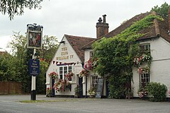
 The King William IV is one of two pubs of the village | |
 Daws Dene refers to part of the Sheepleas and adjoining public woodlands of the North Downs | |
Location within Surrey | |
| Area | 10.83 km2 (4.18 sq mi) |
| Population | 2,828 (Civil Parish 2011)[1] |
| • Density | 261/km2 (680/sq mi) |
| OS grid reference | TQ0752 |
| Civil parish |
|
| District | |
| Shire county | |
| Region | |
| Country | England |
| Sovereign state | United Kingdom |
| Post town | Leatherhead |
| Postcode district | KT24 |
| Dialling code | 01483 |
| Police | Surrey |
| Fire | Surrey |
| Ambulance | South East Coast |
| UK Parliament | |
West Horsley is a semi-rural village between Guildford and Leatherhead in Surrey, England. It lies on the A246, and south of the M25 and the A3. Its civil parish ascends to an ancient woodland Sheepleas Woods which are on the northern downslopes of the ridge of hills known as the North Downs in the extreme south of the village, and cover about a tenth of its area, 255 acres (1 km2). The bulk of its land is north of the Surrey Hills AONB; the rest is within it.
- ^ Key Statistics; Quick Statistics: Population Density United Kingdom Census 2011 Office for National Statistics Retrieved 21 November 2013
