| West Humboldt Range | |
|---|---|
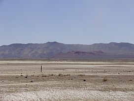
 View of Topog Peak and the westernmost part of the West Humboldt Range from U.S. Route 95 near the junction with Interstate 80 | |
| Highest point | |
| Elevation | 1,876 m (6,155 ft) |
| Geography | |
| Country | United States |
| State | Nevada |
| District | Pershing County and Churchill County |
| City | Lovelock, NV |
| Range coordinates | 40°3′21.680″N 118°21′54.516″W / 40.05602222°N 118.36514333°W |
| Borders on | Humboldt Sink, Humboldt Lake, Carson Sink, Carson Desert, Humboldt River-(west range border) |
| Topo map | USGS Wildhorse Spring |
The West Humboldt Range is a short mountain range in the western Great Basin in northwestern Nevada in the United States.
