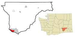
West Pasco, Washington | |
|---|---|
 Location of West Pasco, Washington | |
| Coordinates: 46°15′9″N 119°10′58″W / 46.25250°N 119.18278°W | |
| Country | United States |
| State | Washington |
| County | Franklin |
| Area | |
• Total | 3.7 sq mi (9.7 km2) |
| • Land | 3.7 sq mi (9.7 km2) |
| • Water | 0.0 sq mi (0.0 km2) |
| Elevation | 361 ft (110 m) |
| Population (2020) | |
• Total | 1,747 |
| • Density | 470/sq mi (180/km2) |
| Time zone | UTC-8 (Pacific (PST)) |
| • Summer (DST) | UTC-7 (PDT) |
| ZIP code | 99301[1] |
| Area code | 509 |
| FIPS code | 53-77612[2] |
| GNIS feature ID | 1867645[3] |
West Pasco is a census-designated place (CDP) in Franklin County, Washington, United States. The population was 1,747 at the 2020 census,[4] a significant decrease from 3,739 at the 2010 census.[5]
Based on per capita income, one of the more reliable measures of affluence, West Pasco ranks 47th of 522 areas in the state of Washington to be ranked. It is also the highest rank achieved in Franklin County. The city of Pasco, Washington, as of 2012, was attempting to annex all of West Pasco,[6] although there was some resistance.[7]
- ^ "West Pasco WA ZIP Code". zipdatamaps.com. 2023. Retrieved June 16, 2023.
- ^ "U.S. Census website". United States Census Bureau. Retrieved January 31, 2008.
- ^ "US Board on Geographic Names". United States Geological Survey. October 25, 2007. Retrieved January 31, 2008.
- ^ "Census Bureau profile: West Pasco, Washington". United States Census Bureau. May 2023. Retrieved May 10, 2024.
- ^ "Geographic Identifiers: 2010 Demographic Profile Data (G001): West Pasco CDP, Washington". U.S. Census Bureau, American Factfinder. Retrieved October 24, 2016.[dead link]
- ^ "Pasco, WA – Official Website – Annexation Information". City Of Pasco. Retrieved October 13, 2012.
- ^ "Pasco doughnut hole residents threaten secession vote". Tri-City Herald. June 14, 2012. Retrieved October 13, 2012.