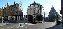
 Main Point, the historic junction of the three roads (2nd l. to r.) to Biggar, Glasgow and Stirling | |
| Former name(s) | Wester Portsburgh |
|---|---|
| Length | 0.2 mi (0.32 km) |
| Coordinates | 55°56′47″N 3°12′00″W / 55.94639°N 3.20000°W |
| west end | Main Point |
| east end | Grassmarket |
The West Port is a street in Edinburgh's Old Town, just south of Edinburgh Castle. It runs from Main Point (the junction of Bread Street, Lauriston Street, East Fountainbridge and High Riggs) to the southwest corner of the Grassmarket.
The street takes its name from the westernmost of the "ports" or gates in the Flodden Wall. The gate stood at the Grassmarket and opened onto the suburb of Portsburgh until it was demolished in the 1780s.[1]
- ^ "Heriot Place and Vennel, Bastion of Flodden Wall, and Telfer Wall (Section)". Historic Environment Scotland. Archived from the original on 18 September 2018. Retrieved 10 February 2024.