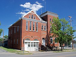
West Salem, Ohio | |
|---|---|
 City Hall (1899) | |
 Location of West Salem, Ohio | |
 Location of West Salem in Wayne County | |
| Coordinates: 40°58′10″N 82°06′29″W / 40.96944°N 82.10806°W | |
| Country | United States |
| State | Ohio |
| County | Wayne |
| Area | |
| • Total | 1.07 sq mi (2.77 km2) |
| • Land | 1.07 sq mi (2.76 km2) |
| • Water | 0.00 sq mi (0.01 km2) |
| Elevation | 1,093 ft (333 m) |
| Population (2020) | |
| • Total | 1,430 |
| • Density | 1,340.21/sq mi (517.36/km2) |
| Time zone | UTC-5 (Eastern (EST)) |
| • Summer (DST) | UTC-4 (EDT) |
| ZIP code | 44287 |
| Area code | 419 |
| FIPS code | 39-84196 |
| GNIS feature ID | 2400143[2] |
| Website | westsalemvillage.com |
West Salem is a village in Wayne County, Ohio. The population was 1,430 at the time of the 2020 census. West Salem is served by a branch of the Wayne County Public Library.[3]
- ^ "ArcGIS REST Services Directory". United States Census Bureau. Retrieved September 20, 2022.
- ^ a b U.S. Geological Survey Geographic Names Information System: West Salem, Ohio
- ^ "Hours & Contact Information". Wayne County Public Library. Archived from the original on August 8, 2016. Retrieved June 10, 2016.