West Slope, Oregon | |
|---|---|
Census-designated place (CDP) | |
 Post office in West Slope | |
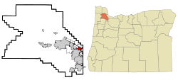
 Location of West Slope, Oregon | |
| Coordinates: 45°29′58″N 122°44′58″W / 45.49944°N 122.74944°W | |
| Country | United States |
| State | Oregon |
| County | Washington |
| Area | |
• Total | 1.62 sq mi (4.19 km2) |
| • Land | 1.62 sq mi (4.19 km2) |
| • Water | 0.00 sq mi (0.00 km2) |
| Elevation | 243 ft (74 m) |
| Population | |
• Total | 7,223 |
| • Density | 4,469.68/sq mi (1,725.46/km2) |
| Time zone | UTC-8 (Pacific (PST)) |
| • Summer (DST) | UTC-7 (PDT) |
| ZIP code | 97225 |
| Area code | 503 |
| FIPS code | 41-80900[4] |
| GNIS feature ID | 2409568[2] |
West Slope is an unincorporated suburb, neighborhood of Beaverton, Oregon, United States and a census-designated place. It is in Washington County, to the east of Cedar Hills, to the northwest of Raleigh Hills and south of U.S. Route 26. Fire protection and EMS services are provided through Tualatin Valley Fire and Rescue.[5]
As of the 2000 census, the suburb population was 6,442. In a plan agreed to by the county and Beaverton, West Slope was scheduled for annexation to Beaverton by 2010.[6]
- ^ "ArcGIS REST Services Directory". United States Census Bureau. Retrieved October 12, 2022.
- ^ a b U.S. Geological Survey Geographic Names Information System: West Slope, Oregon
- ^ Cite error: The named reference
USCensusDecennial2020CenPopScriptOnlywas invoked but never defined (see the help page). - ^ "U.S. Census website". United States Census Bureau. Retrieved January 31, 2008.
- ^ "About TVF&R". Tualatin Valley Fire & Rescue. Retrieved March 13, 2014.
- ^ "Annexation FAQs". Beaverton Community Development. Beaverton, Oregon. 2007. Retrieved March 20, 2007.