West Yorkshire | |
|---|---|
Aspley Basin on the Broad Canal (Huddersfield), the Piece Hall (Halifax) and Ilkley Moor (near Ilkley) | |
 West Yorkshire within England | |
| Coordinates: 53°45′N 1°40′W / 53.750°N 1.667°W | |
| Sovereign state | United Kingdom |
| Constituent country | England |
| Region | Yorkshire and the Humber |
| Established | 1 April 1974 |
| Preceded by | West Riding of Yorkshire |
| Origin | Local Government Act 1972 |
| Time zone | UTC+0 (GMT) |
| • Summer (DST) | UTC+1 (BST) |
| UK Parliament | List of MPs |
| Police | West Yorkshire Police |
| Ceremonial county | |
| Lord Lieutenant | Edmund Anderson |
| High Sheriff | Adeeba Malik (2024-2025)[1] |
| Area | 2,029 km2 (783 sq mi) |
| • Rank | 29th of 48 |
| Population (2022)[2] | 2,378,148 |
| • Rank | 4th of 48 |
| Density | 1,172/km2 (3,040/sq mi) |
| Ethnicity |
|
| Metropolitan county | |
| Government | West Yorkshire Combined Authority |
| Mayor | Tracy Brabin (L) |
| Admin HQ | Leeds |
| GSS code |
|
| ITL | TLE4 |
| Website | westyorks-ca |
| Districts | |
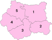
 Districts of West Yorkshire Metropolitan districts | |
| Districts | |
West Yorkshire is a metropolitan and ceremonial county in the Yorkshire and the Humber region of England. It borders North Yorkshire to the north and east, South Yorkshire and Derbyshire to the south, Greater Manchester to the south-west, and Lancashire to the west. The city of Leeds is the largest settlement.
The county, established in 1974, has an area of 2,029 km2 (783 sq mi) and a population of 2.3 million, making it the fourth-largest ceremonial county by population. Large parts of West Yorkshire are urban; many settlements are part of the West Yorkshire built-up area, which has a population of 1.78 million. The largest settlements are Leeds (516,298), Bradford (366,187), Huddersfield (162,949), and Wakefield (109,766). The west of the county is more rural. The county is governed by five metropolitan boroughs: City of Bradford, Calderdale, Kirklees, City of Leeds and City of Wakefield, which collaborate through West Yorkshire Combined Authority.
The western part of West Yorkshire is in the South Pennines, and contains a small part of the Peak District National Park. It is characterised by steep valleys and is the source of the River Calder, which flows past Wakefield before meeting the Aire, which flows through Leeds, near Castleford. The landscape becomes flatter in the east, and the county boundary is on the edge of the Vale of York.
Remnants of strong coal, wool and iron ore industries remain in the county, having attracted people over the centuries, and this can be seen in the buildings and architecture. Several railways and the M1, M621, M606, A1(M) and M62 motorways traverse the county.
- ^ "No. 64345". The London Gazette. 14 March 2024. p. 5286.
- ^ "Mid-2022 population estimates by Lieutenancy areas (as at 1997) for England and Wales". Office for National Statistics. 24 June 2024. Retrieved 26 June 2024.
- ^ "West Yorkshire Demographics | Age, Ethnicity, Religion, Wellbeing". Varbes. Retrieved 10 February 2023.


