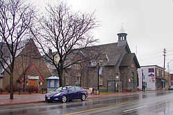
Westboro | |
|---|---|
Neighbourhood | |
 Former Westboro Town Hall | |
| Coordinates: 45°23′50″N 75°44′36″W / 45.39722°N 75.74333°W | |
| Country | Canada |
| Province | Ontario |
| City | Ottawa |
| Established | 19th Century |
| Incorporated | 1905 (Police Village of Westboro) |
| Annexation | 1949 (City of Ottawa) |
| Government | |
| • MPs | Yasir Naqvi, Anita Vandenbeld |
| • MPPs | Joel Harden, Chandra Pasma |
| • Councillors | Jeff Leiper, Theresa Kavanagh |
| Elevation | 70 m (230 ft) |
| Population (2016) | |
| • Total | 22,725 |
| Canada 2016 Census | |
| Time zone | UTC−5 (Eastern (EST)) |
| • Summer (DST) | UTC−4 (EDT) |
Westboro (often referred to as Westboro Village) is an area in the west end of Ottawa, Ontario, Canada. Located along the Ottawa River, Island Park Drive defines Westboro's eastern border, while the Ottawa River defines its northern border. Under this definition, the population of the area is 22,725 (2016 Census).[1]
Its community association boundaries are the Transitway to the north, Tweedsmuir Avenue to the east, Carling Avenue to the south and Denbury Avenue to the west.[2] This area excludes the neighbourhood of Westboro Beach, whose community association borders include the area immediately north of Westboro, west of Island Park Drive.
- ^ Population calculated by combining Census Tracts 5050032.01, 5050032.02, 5050033.01, 5050033.02 with Dissemination areas 35061863, 35061864, 35061862, 35061865, 35061866, 35061867 and 35061868.
- ^ "Community Associations |". Archived from the original on May 14, 2014. Retrieved September 28, 2013.
