Westchase | |
|---|---|
Business district of Houston, Texas | |
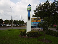
 Marker of the Westchase District | |
 | |
| Coordinates: 29°43′44″N 95°33′50″W / 29.729°N 95.564°W | |
| Country | |
| State | |
| County | Harris |
| City | |
| Government | |
| • Type | Special district |
| • Body | Westchase Management District |
| Area | |
• Total | 11.2 km2 (4.32 sq mi) |
| Population (2012)[1] | |
• Total | 26,122 |
| • Density | 2,300/km2 (6,000/sq mi) |
| Time zone | Central Standard Time (CST) |
| ZIP Code | 77057, 77063 |
| Area codes | 281, 346, 713, 832 |
| Website | westchasedistrict |
Westchase is a business district and neighborhood in western Houston, Texas, bounded by Westheimer Road on the north, Gessner Road on the east, Houston Center Boulevard on the west, and Westpark Tollway on the south.[1] The area is bisected by Beltway 8. Westchase is adjacent to Greater Sharpstown, the International District (which includes part of Chinatown), and the Royal Oaks Country Club subdivision. The area is immediately northeast of Alief.
A large portion of Westchase is covered by a special district, the Westchase Management District, which was created by the Texas Legislature in 1995.[2] This entity, funded by a tax increment on businesses within its boundaries, provides branding, urban planning, and public safety functions for its constituents.[3]
More than 1,500 businesses reside in Westchase; several are associated with the petroleum industry, for which Houston is considered a major capital. Major employers that have offices in Westchase include ABB Group, BMC Software, Chevron, Phillips 66, Dow Chemical, Petrochina, and Jacobs Engineering.[4] The Westchase management district is approximately 4.32 square miles (11.2 km2) in size, with 16.3 million square feet (1,510,000 m2) of office space contained in 118 buildings.[5]
In 2006 Westchase was described by John Nova Lomax of the Houston Press as suburban in nature, with a high concentration of chain stores along its major arterial roads.[6]
- ^ a b c "Super Neighborhood Resource Assessment: Westchase" (PDF). City of Houston Planning and Development Department. August 2014. Retrieved 28 February 2017.
- ^ "HB 3204" (PDF). Legislative Reference Library of Texas. 5 April 1995. Retrieved 28 February 2017.
- ^ "Municipal Management Districts" (PDF). Texas Legislative Reference Library. Allen Boone Humpheries Robinson LLP. Retrieved 25 February 2017.
- ^ "About Westchase." Westchase. Retrieved on February 5, 2009.
- ^ "Westchase District Land Use Map" (PDF). Westchase Management District. Archived from the original (PDF) on 2014-05-12. Retrieved 2019-08-14.
- ^ Lomax, John Nova. "The Sole of Houston." Houston Press. October 12, 2006. 3. "[...]And Westchase is huge -- it runs all the way from west of Wilcrest damn near to Fondren. It's virtually all chains -- a Geography of Nowhere wasteland of Boston Market, Borders, Kroger, Randalls, Taco Bell, Citgo and Sonic.[...]"