Western Islands | |
|---|---|
| Other transcription(s) | |
| • Chinese | 西部群岛 |
| • Pinyin | Xībù qúndǎo |
| • Malay | Kepulauan Barat |
| • Tamil | மேற்கத்திய தீவுகள் |
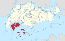
 Location of Western Islands in Singapore | |
| Country | |
| Region | West
|
| Government | |
| • Mayors | South West CDC
|
| • Members of Parliament | West Coast GRC |
| Area | |
| • Total | 39.47 km2 (15.24 sq mi) |
| Population (2022) | |
| • Total | 10 |
| • Density | 0.25/km2 (0.66/sq mi) |
| Ethnic groups | |
The Western Islands is a planning area located within the West Region of Singapore. It comprises a collection of islands located in the south-western waters of Singapore, namely Jurong Island, Pulau Bukom, and Sudong Islands.[1]
The Western Islands originally comprised 27 islands, once home to the native Malay islanders in the past. In the 1990s, the government decided to reclaim land to form one major island, called Jurong Island. It was subsequently formed from the amalgamation of several offshore islands, chiefly the seven main islands of Pulau Ayer Chawan, Pulau Ayer Merbau, Pulau Merlimau, Pulau Pesek Besar, Pulau Pesek Kechil, Pulau Sakra, Pulau Soraya, Pulau Hantu Besar, and Pulau Hantu Kechil.
The planning area is located on the Singapore Straits, with Tuas situated to its west, as well as Pioneer, Boon Lay, Jurong East and Queenstown to its north. Western Islands planning area also shares a maritime boundary with the Southern Islands to its east.