| Western Pomerania Lagoon Area National Park | |
|---|---|
| Nationalpark Vorpommersche Boddenlandschaft | |
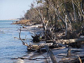
 Coastal vegetation | |
| Location | Mecklenburg-Vorpommern, Germany |
| Nearest city | Rostock and Stralsund |
| Coordinates | 54°26′10″N 12°54′32″E / 54.436°N 12.909°E |
| Area | 805 km2 (311 sq mi) |
| Established | 1 October 1990 |
The Western Pomerania Lagoon Area National Park[1] (Nationalpark Vorpommersche Boddenlandschaft) is Mecklenburg-Vorpommern's largest national park, situated at the coast of the Baltic Sea. It consists of several peninsulas, islands and lagoon shore areas in the Baltic Sea, belonging to the district of Vorpommern-Rügen.
The national park includes:
- the Darß peninsula
- the western coast of the island of Rügen
- the island of Hiddensee
- the island of Ummanz
- several tiny islets between the above places
- the multiple lagoons in between the land masses
The national park is characterised by very shallow water housing a unique coastal fauna. All portions of the national park are famous for being a resting place for tens of thousands of cranes and geese.
Its area is 805 km2 (311 sq mi).
- ^ Western Pomerania Lagoon Area at www.naturefund.de. Accessed on 27 June 2012. Archived 2 July 2013 at the Wayback Machine
