Western Rukum District
पश्चिमी रुकुम | |
|---|---|
 | |
 Location of West Rukum District (dark yellow) in Karnali | |
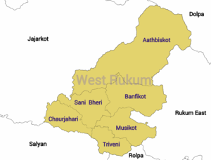
 Division of West Rukum | |
| Coordinates: 28°38′N 82°29′E / 28.63°N 82.49°E | |
| Country | |
| Province | Karnali Province |
| Established | 2015 |
| Admin HQ. | Musikot |
| Government | |
| • Type | Coordination committee |
| • Body | DCC, Western Rukum |
| Area | |
| • Total | 1,213.49 km2 (468.53 sq mi) |
| Population | |
| • Total | 154,272 |
| • Density | 130/km2 (330/sq mi) |
| Time zone | UTC+05:45 (NPT) |
| Website | dccrukumwest |
Western Rukum (Nepali: पश्चिमी रुकुम ) a part of Karnali Province, is one of the seventy-seven districts of Nepal.[1] Musikot is the headquarter of the district.
Formally Western Rukum District was part of Rukum District, which divided into two districts Western Rukum and Eastern Rukum after the state's reconstruction of administrative divisions as of 20 September 2015.
The total area of Western Rukum District is 1,213.49 square kilometres (468.53 sq mi) and total population of this district as of 2011 Nepal census is 154,272 individuals.[1][2]
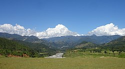
Located in the western hill region, Western Rukum is a hill district with many valleys. It is bordered with five districts: Eastern Rukum and Rolpa district of Lumbini province on the east, Salyan district to the south, Jajarkot district on the west, and Dolpa district to the north.
- ^ a b "स्थानीय तहहरुको विवरण" [Details of local level body]. www.mofald.gov.np (in Nepali). Ministry of Federal Affairs and Local Development (Nepal). Retrieved 14 April 2018.
- ^ "CITY POPULATION– statistics, maps & charts". www.citypopulation.de. 8 October 2017. Retrieved 14 April 2018.