Weston, Oregon | |
|---|---|
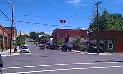
 Historic Main street. | |
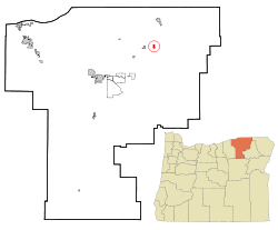
 Location in Oregon | |
| Coordinates: 45°48′59″N 118°25′33″W / 45.81639°N 118.42583°W | |
| Country | United States |
| State | Oregon |
| County | Umatilla |
| Incorporated | 1878 |
| Area | |
| • Total | 0.68 sq mi (1.76 km2) |
| • Land | 0.68 sq mi (1.76 km2) |
| • Water | 0.00 sq mi (0.00 km2) |
| Elevation | 1,821 ft (555 m) |
| Population | |
| • Total | 706 |
| • Density | 1,038.24/sq mi (400.92/km2) |
| Time zone | UTC-8 (Pacific) |
| • Summer (DST) | UTC-7 (Pacific) |
| ZIP code | 97886 |
| Area code | 541 |
| FIPS code | 41-80350[4] |
| GNIS feature ID | 2412241[2] |
Weston is a city in Umatilla County, Oregon, United States. It was originally a post office called Mitchell's Station, established in February 1867. In September 1869, T.T. Lieuallen renamed the post office after his hometown, Weston, Missouri.[5] The population was 667 at the 2010 census. It is part of the Pendleton–Hermiston Micropolitan Statistical Area.
- ^ "ArcGIS REST Services Directory". United States Census Bureau. Retrieved October 12, 2022.
- ^ a b U.S. Geological Survey Geographic Names Information System: Weston, Oregon
- ^ Cite error: The named reference
USCensusDecennial2020CenPopScriptOnlywas invoked but never defined (see the help page). - ^ Cite error: The named reference
wwwcensusgovwas invoked but never defined (see the help page). - ^ McArthur, Lewis A.; McArthur, Lewis L. (2003) [1928]. Oregon Geographic Names (7th ed.). Portland, Oregon: Oregon Historical Society Press. p. 1025. ISBN 978-0875952772.