Westport, Massachusetts
Acoaxet | |
|---|---|
 Stone wall and field scene, Westport | |
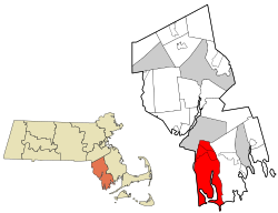
 Location in Bristol County in Massachusetts | |
| Coordinates: 41°38′20″N 71°03′00″W / 41.63889°N 71.05000°W | |
| Country | United States |
| State | Massachusetts |
| County | Bristol |
| Settled | 1670 |
| Incorporated | 1787 |
| Government | |
| • Type | Open town meeting |
| Area | |
| • Total | 64.4 sq mi (166.8 km2) |
| • Land | 50.1 sq mi (129.6 km2) |
| • Water | 14.3 sq mi (37.1 km2) |
| Elevation | 50 ft (15 m) |
| Population (2020) | |
| • Total | 16,339 |
| • Density | 250/sq mi (98/km2) |
| Time zone | UTC-5 (Eastern) |
| • Summer (DST) | UTC-4 (Eastern) |
| ZIP code | 02790 |
| Area code | 508 / 774 |
| FIPS code | 25-77570 |
| GNIS feature ID | 0618287 |
| Website | http://www.westport-ma.com |
Westport (Massachusett: Acoaxet[1]) is a town in Bristol County, Massachusetts, United States. The population was 16,339 at the 2020 census.[2]
The village of North Westport lies in the town. Other named areas of the town are "Westport Point," which has a dock on the Westport River where Main Road meets the river; "Central Village" with town offices, retail stores and businesses; "Head of Westport" at the head of the east branch of the river; and the area referred to either as "Acoaxet" or "Westport Harbor," which is between the west branch of the river and Rhode Island. This area is cut off from the rest of Massachusetts by water and Rhode Island.
Westport is a part of the South Coast region of Massachusetts which encompasses the cities and towns that surround Buzzards Bay (excluding the Elizabeth Islands, Bourne and Falmouth), Mount Hope Bay and the Sakonnet River.
- ^ Ricketson, Daniel (1858). The history of New Bedford, Bristol County, Massachusetts including a history of the old township of Dartmouth and the present townships of Westport, Dartmouth, and Fairhaven, from their settlement to the present time. D. Ricketson. p. 13. OCLC 1263627689.
- ^ "Census - Geography Profile: Westport town, Massachusetts". United States Census Bureau. Retrieved November 11, 2021.
