| Whaley Bridge | |
|---|---|
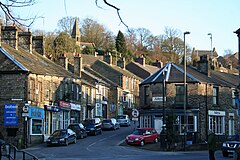
 Whaley Bridge town centre | |
Location within Derbyshire | |
| Population | 6,455 (Parish, 2011)[1] |
| OS grid reference | SK 012 815 |
| District | |
| Shire county | |
| Region | |
| Country | England |
| Sovereign state | United Kingdom |
| Post town | HIGH PEAK[2] |
| Postcode district | SK23 |
| Dialling code | 01663 |
| Police | Derbyshire |
| Fire | Derbyshire |
| Ambulance | East Midlands |
| UK Parliament | |
Whaley Bridge (/ˈhweɪli/) is a town and civil parish in the High Peak district of Derbyshire, England. It is situated on the River Goyt, 16 miles (26 km) south-east of Manchester, 7 miles (11 km) north of Buxton, 9 miles (14 km) north-east of Macclesfield and 28 miles (45 km) west of Sheffield. It had a population of 6,455 at the 2011 census,[1] including Furness Vale, Horwich End, Bridgemont, Fernilee, Stoneheads and Taxal.
- ^ a b UK Census (2011). "Local Area Report – Whaley Bridge Parish (1170212884)". Nomis. Office for National Statistics. Retrieved 17 March 2018.
- ^ Royal Mail, Postcode Update 23, July 1996
