Wharekahika / Hicks Bay | |
|---|---|
Town | |
 | |
 | |
| Coordinates: 37°36′S 178°18′E / 37.600°S 178.300°E | |
| Country | New Zealand |
| Region | Gisborne District |
| Ward | Tairāwhiti General Ward |
| Electorates | |
| Area | |
| • Total | 1.28 km2 (0.49 sq mi) |
| Population (June 2024)[2] | |
| • Total | 190 |
| • Density | 150/km2 (380/sq mi) |
| Postcode(s) | 4087 |
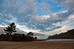
Wharekahika or Hicks Bay (officially Wharekahika / Hicks Bay) is a bay and coastal area in the Gisborne District of the North Island of New Zealand. It is situated 150 km east of Ōpōtiki and 186 km north of Gisborne city, along State Highway 35 between Potaka and Te Araroa.[3]
The area is named after Zachary Hickes, second-in-command of James Cook's Endeavour, which sailed along the East Cape on 31 October 1769.[4] On 10 June 2019, the name of the bay was officially changed to Wharekahika / Hicks Bay.[5]
- ^ Cite error: The named reference
Areawas invoked but never defined (see the help page). - ^ "Aotearoa Data Explorer". Statistics New Zealand. Retrieved 26 October 2024.
- ^ Hariss, Gavin. "Hicks Bay, Gisborne". topomap.co.nz. NZ Topo Map.
- ^ "Hicks Bay - Wharekahika". gisbornenz. Gisborne NZ Tourism.
- ^ "NZGB notices – June 2019". Land Information New Zealand. 25 June 2019. Retrieved 25 June 2019.