Whataroa | |
|---|---|
Town | |
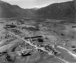
 Whites Aviation photo of Whataroa in 1958 | |
| Coordinates: 43°15′42″S 170°21′32″E / 43.26167°S 170.35889°E | |
| Country | New Zealand |
| Region | West Coast |
| District | Westland District |
| Electorates | West Coast-Tasman Te Tai Tonga |
| Population (2013) | |
• Total | 288 |
| Time zone | UTC+12 (NZST) |
| • Summer (DST) | UTC+13 (NZDT) |
| Postcode | 7886 |
| Area code | 03 |
| Local iwi | Ngāi Tahu |
Whataroa is a small township in southern Westland on the West Coast of New Zealand's South Island. It is located on alluvial flats to the west of the Whataroa River. State Highway 6 passes through Whataroa on its route from Ross to Franz Josef / Waiau. Hari Hari is 31 kilometres (19 mi) to the north-east, and Franz Josef is 32 km to the south-west.[1][2]
The population of Whataroa and its surrounding area was 288 in the 2013 census, a decrease of 117 from 2006.[3]
Whataroa is located in an agricultural area where dairying is the primary activity. The town contains establishments such as a school, two churches, and a dairy and tearooms. Whataroa is the base for tours of the nearby Waitangiroto Nature Reserve, the location of the only breeding colony of kōtuku or white heron (Ardea alba modesta) in New Zealand.
- ^ Peter Dowling, ed. (2004). Reed New Zealand Atlas. Reed Books. map 74. ISBN 978-0-7900-0952-0.
- ^ Roger Smith, GeographX (2005). The Geographic Atlas of New Zealand. Robbie Burton. map 173. ISBN 978-1-877333-20-0.
- ^ 2013 Census QuickStats about a place : Whataroa
