Whau Valley | |
|---|---|
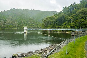
 Whau Valley earth dam | |
 | |
| Coordinates: 35°41′55″S 174°18′46″E / 35.69861°S 174.31278°E | |
| Country | New Zealand |
| City | Whangārei |
| Local authority | Whangarei District Council |
| Electoral ward | Whangārei Urban Ward |
| Area | |
| • Land | 718 ha (1,774 acres) |
| Population (June 2024)[2] | |
• Total | 2,880 |
| Postcode(s) | 0112 |
| Kamo | Otangarei | |
|
|
Mairtown | |
| (Pukenui Forest) | Regent | Kensington |
Whau Valley is a suburb of Whangārei, in Northland Region, New Zealand. State Highway 1 runs through it.[3] The valley was named for the whau trees which grew there in the 1850s.[4]
At the end of the 4 km long Whau Valley Road is the principal water reservoir for Whangārei City, created by the Whau Valley Earth Dam. The reservoir is stocked with rainbow and brown trout.[5][6]
- ^ Cite error: The named reference
Areawas invoked but never defined (see the help page). - ^ "Aotearoa Data Explorer". Statistics New Zealand. Retrieved 26 October 2024.
- ^ Roger Smith, GeographX (2005). The Geographic Atlas of New Zealand. Robbie Burton. pp. map 24. ISBN 1-877333-20-4.
- ^ Pickmere, Nancy Preece (1986). Whangarei: The Founding Years. p. 70.
- ^ Parkes, W. F. (1992). Guide to Whangarei City and District. p. 54. ISBN 0-473-01639-7.
- ^ "Northland Fishing". Fish & Game New Zealand. Retrieved 8 May 2008.