| Whernside | |
|---|---|
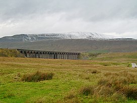
 A snow-covered Whernside and Ribblehead Viaduct seen from Ribblehead | |
| Highest point | |
| Elevation | 736 m (2,415 ft)[1] |
| Prominence | 408 m (1,339 ft) |
| Parent peak | Cross Fell |
| Listing | Marilyn, Hewitt, Hardy, County Top, Nuttall |
| Coordinates | 54°13′40″N 2°24′12″W / 54.22764°N 2.40338°W |
| Geography | |
| OS grid | SD738814 |
| Topo map | OS Landranger 98 |
Whernside is a mountain in the Yorkshire Dales in Northern England. It is the highest of the Yorkshire Three Peaks,[2] the other two being Ingleborough and Pen-y-ghent. It is the highest point in the ceremonial county of North Yorkshire[1][note 1] and the historic West Riding of Yorkshire with the summit lying on the county boundary with Cumbria. It is the fifteenth most prominent hill in England.[3]
In shape Whernside forms a long ridge, running roughly north-north-east to south-south-west. The mountain is 6 miles (10 km) north west of Ingleton and 6 miles (10 km) north of Horton-in-Ribblesdale.[4]
- ^ a b Bathurst, David (2012). Walking the county high points of England. Chichester: Summersdale. pp. 250–255. ISBN 978-1-84-953239-6.
- ^ "Powerful image for Whernside". Craven Herald & Pioneer. 15 October 2009. Retrieved 30 November 2016.
- ^ "Marilyns of England". www.peakbagger.com. Retrieved 25 November 2020.
- ^ "98" (Map). Wensleydale & Upper Wharfedale. 1:50,000. Landranger. Ordnance Survey. 2016. ISBN 9780319261965.
Cite error: There are <ref group=note> tags on this page, but the references will not show without a {{reflist|group=note}} template (see the help page).
