| Whissonsett | |
|---|---|
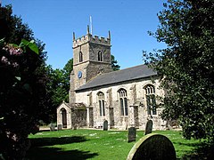
 St Mary's church, Whissonsett | |
Location within Norfolk | |
| Area | 5.57 km2 (2.15 sq mi) |
| Population | 488 (2011 census)[1] |
| • Density | 88/km2 (230/sq mi) |
| OS grid reference | TF916230 |
| • London | 112 miles (180 km) |
| Civil parish |
|
| District | |
| Shire county | |
| Region | |
| Country | England |
| Sovereign state | United Kingdom |
| Post town | DEREHAM |
| Postcode district | NR20 |
| Dialling code | 01328 |
| Police | Norfolk |
| Fire | Norfolk |
| Ambulance | East of England |
| UK Parliament | |
| Website | http://www.whissonsett.com |
Whissonsett is a village and a civil parish in the English county of Norfolk.[2] The village is 5.0 miles (8.0 km) south of Fakenham, 23 miles (37 km) west-north-west of Norwich and 112 miles (180 km) north-north-east of London. The nearest railway station is at King's Lynn for the Fen Line which runs between King's Lynn and Cambridge. The nearest airport is Norwich International Airport. The parish had in 2001 census, a population of 483 in 206 households,[3] increasing to a population of 488 in 209 households at the 2011 Census. For the purposes of local government, the parish falls within the district of Breckland. The village lies close to the source of the River Wensum.
- ^ "Civil Parish population 2011". Neighbourhood Statistics. Office for National Statistics. Retrieved 15 August 2016.
- ^ OS Explorer Map 238 – Dereham & Aylsham, Castle Acre & Reepham. ISBN 0-319-23810-5
- ^ Office for National Statistics & Norfolk County Council, 2001. "Census population and household counts for unparished urban areas and all parishes Archived 2017-02-11 at the Wayback Machine."
