White Cloud, Kansas | |
|---|---|
 White Cloud (1974) | |
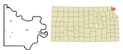
 Location within Doniphan County and Kansas | |
 | |
| Coordinates: 39°58′28″N 95°17′57″W / 39.97444°N 95.29917°W[1] | |
| Country | United States |
| State | Kansas |
| County | Doniphan |
| Founded | 1855 |
| Platted | 1857 |
| Incorporated | 1862 |
| Named for | Francis White Cloud |
| Area | |
| • Total | 0.72 sq mi (1.88 km2) |
| • Land | 0.72 sq mi (1.88 km2) |
| • Water | 0.00 sq mi (0.00 km2) |
| Elevation | 879 ft (268 m) |
| Population | |
| • Total | 115 |
| • Density | 160/sq mi (61/km2) |
| Time zone | UTC-6 (CST) |
| • Summer (DST) | UTC-5 (CDT) |
| ZIP code | 66094 [4] |
| Area code | 785 |
| FIPS code | 20-77850 |
| GNIS ID | 2397301[1] |
| Website | City website |
White Cloud (Ioway: Chína Maxúthga pronounced [tʃʰiꜜnã mãxuθꜜkɐ] or Chína Maxúhga pronounced [tʃʰiꜜnã mãxuhꜜkɐ], meaning "Village Cloud-White") is a city in Doniphan County, Kansas, United States.[1] As of the 2020 census, the population of the city was 115.[3] It was named for Francis White Cloud, a son of Chief White Cloud of the Iowa people.[5] White Cloud is the seat of government for the Iowa Tribe of Kansas and Nebraska.
- ^ a b c d U.S. Geological Survey Geographic Names Information System: White Cloud, Kansas
- ^ "2019 U.S. Gazetteer Files". United States Census Bureau. Retrieved July 24, 2020.
- ^ a b "Profile of White Cloud, Kansas in 2020". United States Census Bureau. Archived from the original on June 26, 2022. Retrieved June 26, 2022.
- ^ United States Postal Service (2012). "USPS - Look Up a ZIP Code". Retrieved February 15, 2012.
- ^ Kansas Place-Names, John Rydjord, University of Oklahoma Press, 1972, p. 436 ISBN 0-8061-0994-7