| White Mountains | |
|---|---|
 White Mountain Peak from access road | |
| Highest point | |
| Peak | White Mountain Peak |
| Elevation | 14,252 ft (4,344 m) |
| Coordinates | 37°38′02″N 118°15′20″W / 37.63389°N 118.25556°W |
| Dimensions | |
| Length | 60 mi (97 km) |
| Width | 10 mi (16 km) |
| Geography | |
 The White Mountains along the east side of Owens Valley | |
| Country | United States |
| States |
|
| Range coordinates | 37°35.0′N 118°16.05′W / 37.5833°N 118.26750°W |
| Parent range | Basin and Range Province |
| Borders on | |
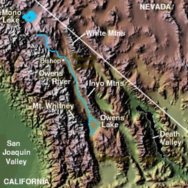
The White Mountains of California and Nevada are a triangular fault-block mountain range facing the Sierra Nevada across the upper Owens Valley. They extend for approximately 60 mi (97 km) as a greatly elevated plateau about 20 mi (32 km) wide on the south, narrowing to a point at the north, with elevations generally increasing south to north. The range's broad southern end is near the community of Big Pine, where Westgard Pass and Deep Springs Valley separate it from the Inyo Mountains. The narrow northern end is at Montgomery Pass, where U.S. Route 6 crosses. The Fish Lake Valley lies east of the range; the southeast part of the mountains are separated from the Silver Peak Range by block faulting across the Furnace Creek Fault Zone, forming a feeder valley to Fish Lake Valley. The range lies within the eastern section of the Inyo National Forest.