| White River Rio Blanco | |
|---|---|
 The White River in Uintah County, Utah | |
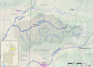
 Map of the White River watershed | |
| Location | |
| Country | United States |
| State | Colorado, Utah |
| Cities | Meeker, Colorado, Rangely, Colorado, Bonanza, Utah, Ouray, Utah |
| Physical characteristics | |
| Source | Confluence of North Fork and South Fork |
| • location | Rio Blanco County, Colorado |
| • coordinates | 39°58′22″N 107°38′18″W / 39.97278°N 107.63833°W[1] |
| • elevation | 6,932 ft (2,113 m) |
| Mouth | Green River |
• location | Uintah County, Utah |
• coordinates | 40°03′44″N 109°40′45″W / 40.06222°N 109.67917°W[1] |
• elevation | 4,646 ft (1,416 m) |
| Length | 195 mi (314 km) |
| Basin size | 5,120 sq mi (13,300 km2) |
| Discharge | |
| • location | Watson, Utah[2] |
| • average | 689 cu ft/s (19.5 m3/s)[3] |
| • minimum | 13 cu ft/s (0.37 m3/s) |
| • maximum | 8,160 cu ft/s (231 m3/s) |
| Basin features | |
| River system | Colorado River |
| Tributaries | |
| • left | South Fork White River |
| • right | North Fork White River |
White River is a river, approximately 195 miles (314 km) long, in the U.S. states of Colorado and Utah and is a tributary of the Green River (which flows into the Colorado River).[4][1]
- ^ a b c U.S. Geological Survey Geographic Names Information System: White River
- ^ "USGS Gage #09306500 on the White River near Watson, Utah" (PDF). National Water Information System: 1923–present. U.S. Geological Survey. 2009. Retrieved 2011-01-16.
- ^ "USGS Gage #09306500 on the White River near Watson, Utah" (PDF). National Water Information System: 1923–present. U.S. Geological Survey. 2009. Retrieved 2011-01-16.
- ^ The National Map (Map). United States Geological Survey. § National Hydrography Dataset high-resolution flowline data. Retrieved 18 Mar 2011.