| Whitefish Dunes State Park | |
|---|---|
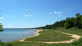
 A Lake Michigan beach in Whitefish Dunes State Park | |
| Location | Door, Wisconsin, United States |
| Coordinates | 44°55′13″N 87°12′16″W / 44.92028°N 87.20444°W |
| Area | 867 acres (351 ha) |
| Established | 1967 |
| Governing body | Wisconsin Department of Natural Resources |
| Website | Whitefish Dunes State Park |
Whitefish Dunes State Park is a 867-acre (351 ha)[2] state park of Wisconsin on the eastern shore of the Door Peninsula. This day-use park preserves the most substantial sand dunes on the western shore of Lake Michigan. The remains of eight successive prehistoric Native American villages[2] are on the National Register of Historic Places as Whitefish Dunes-Bay View Site. Cave Point County Park is an enclave inside the state park,[3] allowing visitors free foot access to the state park by the shoreline trail connecting the parks.
- ^ Protected Planet. "Whitefish Dunes State Park, archived December 27, 2018". United Nations Environment World Conservation Monitoring Centre. Archived from the original on December 27, 2018. Retrieved December 26, 2018.
- ^ a b "History". Whitefish Dunes State Park. Wisconsin DNR. Archived from the original on April 7, 2022. Retrieved April 8, 2022.
- ^ Cave Point County Park kiosk historical notes and Cave Point County Park Archived May 18, 2024, at the Wayback Machine description in Door County Outdoors: A Guide to the Best Hiking, Biking, Paddling, Beaches, and Natural Places by Magill Weber, Madison, Wisconsin: University of Wisconsin Press, 2011, page 169

