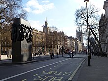
 Whitehall pictured in 2012, with The Cenotaph and Monument to the Women of World War II in the middle of the carriageway, and the Elizabeth Tower housing Big Ben in the background. | |
| Former name(s) | The Street, King Street |
|---|---|
| Part of | A3212 |
| Maintained by | Transport for London |
| Length | 0.4 mi (0.64 km)[1] |
| Location | Westminster, London |
| Postal code | SW1 |
| Nearest Tube station | |
| Coordinates | 51°30′15″N 00°07′35″W / 51.50417°N 0.12639°W |
| North end | Trafalgar Square |
| South end | The Cenotaph |
| Other | |
| Known for | |
Whitehall is a road and area in the City of Westminster, Central London, England. The road forms the first part of the A3212 road from Trafalgar Square to Chelsea. It is the main thoroughfare running south from Trafalgar Square towards Parliament Square. The street is recognised as the centre of the Government of the United Kingdom and is lined with numerous departments and ministries, including the Ministry of Defence, Horse Guards and the Cabinet Office. Consequently, the name "Whitehall" is used as a metonym for the British civil service and government, and as the geographic name for the surrounding area.
The Palace of Whitehall previously occupied the area and was the residence of Kings Henry VIII through to William III, before it was destroyed by fire in 1698; only the Banqueting House has survived. Whitehall was originally a wide road that led to the gates of the palace; the route to the south was widened in the 18th century, following the destruction of the palace, and the area was largely rebuilt for government offices.
As well as government buildings, the street is known for its memorial statues and monuments, including the UK's primary war memorial, the Cenotaph. South of the Cenotaph the thoroughfare becomes Parliament Street. The Whitehall Theatre (now the Trafalgar Studios) was formerly associated with a series of farces.
