This article needs additional citations for verification. (February 2020) |
Whitewater Region | |
|---|---|
| Township of Whitewater Region | |
 Muskrat Lake | |
| Coordinates: 45°43′N 76°50′W / 45.717°N 76.833°W | |
| Country | Canada |
| Province | Ontario |
| County | Renfrew |
| Established | 2001 |
| Government | |
| • Type | Township |
| • Mayor | Neil Nicholson |
| • Governing Body | Township of Whitewater Region Council |
| • MP | Cheryl Gallant (CPC) |
| • MPP | John Yakabuski (OPC) |
| Area | |
| • Land | 535.48 km2 (206.75 sq mi) |
| Population (2021)[1] | |
| • Total | 7,225 |
| • Density | 13.5/km2 (35/sq mi) |
| Time zone | UTC-5 (EST) |
| • Summer (DST) | UTC-4 (EDT) |
| Postal code FSA | K0J |
| Area code(s) | 613, 343 |
| Website | www |
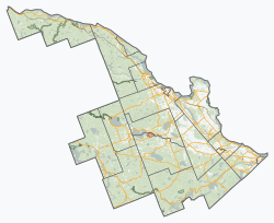
Whitewater Region is a township on the Ottawa River in Renfrew County, located within the Ottawa Valley in eastern Ontario, Canada. Whitewater Region is made up of the former municipalities of Beachburg, Cobden, Ross and Westmeath, which were amalgamated into the current township on January 1, 2001.
Whitewater Region is named after the stretch of whitewater on the Ottawa River, popular for rafting and kayaking. This section is part of the Ottawa River Provincial Park.
The township also claims a distinctive place in Canada's history. An astrolabe bearing the date 1613 and believed to have belonged to Samuel de Champlain was discovered within the township. A monument commemorating this historic site is located just outside Cobden along Highway 17.
- ^ a b "Whitewater Region census profile". 2021 Census of Population. Statistics Canada. February 9, 2022. Retrieved February 29, 2024.

