This article needs additional citations for verification. (November 2007) |
Whitianga | |
|---|---|
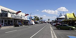
 Albert Street in Whitianga | |
 | |
| Coordinates: 36°50′S 175°42′E / 36.833°S 175.700°E | |
| Country | New Zealand |
| Region | Waikato |
| District | Thames-Coromandel District |
| Ward | Mercury Bay ward |
| Community Board | Mercury Bay Community |
| Electorates | |
| Government | |
| • Council | Thames-Coromandel District Council |
| Area | |
| • Total | 17.20 km2 (6.64 sq mi) |
| Population (June 2023)[2] | |
| • Total | 6,440 |
| • Density | 370/km2 (970/sq mi) |
| Postcode(s) | 3510 |
Whitianga is a town on the Coromandel Peninsula, in the Waikato region of New Zealand's North Island. The town is located on Mercury Bay, on the northeastern coast of the peninsula. The town has a permanent population of 6,440 as of June 2023,[2] making it the second-largest town on the Coromandel Peninsula behind Thames.
- ^ Cite error: The named reference
Areawas invoked but never defined (see the help page). - ^ a b "Subnational population estimates (RC, SA2), by age and sex, at 30 June 1996-2023 (2023 boundaries)". Statistics New Zealand. Retrieved 25 October 2023. (regional councils); "Subnational population estimates (TA, SA2), by age and sex, at 30 June 1996-2023 (2023 boundaries)". Statistics New Zealand. Retrieved 25 October 2023. (territorial authorities); "Subnational population estimates (urban rural), by age and sex, at 30 June 1996-2023 (2023 boundaries)". Statistics New Zealand. Retrieved 25 October 2023. (urban areas)