| Whitworth | |
|---|---|
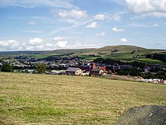
 A view over Whitworth, to Brown Wardle Hill | |
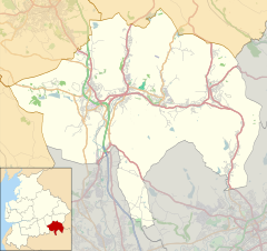
Location within Lancashire | |
| Population | 7,500 (2011 Census) |
| OS grid reference | SD882185 |
| Civil parish |
|
| District | |
| Shire county | |
| Region | |
| Country | England |
| Sovereign state | United Kingdom |
| Post town | ROCHDALE |
| Postcode district | OL12 |
| Dialling code | 01706 |
| Police | Lancashire |
| Fire | Lancashire |
| Ambulance | North West |
| UK Parliament | |
Whitworth is a town and civil parish in Rossendale, Lancashire, England, amongst the foothills of the Pennines between Bacup, to the north, and Rochdale, to the south. It had a population of 7,500 at the 2011 Census.[2]
Whitworth spans the Whitworth Valley, a 7 square miles (18.1 km2) area consisting of Healey, Broadley, Whitworth, Facit and Shawforth, linked by the A671 road.[3] Several smaller hamlets are now part of Whitworth, such as Cowm Top, which was removed to make way for Cowm Reservoir.[4]
Whitworth is twinned with Kandel, Germany.[5]
- ^ "Official website". Retrieved 25 August 2020.
- ^ "Civil Parish population 2011". Retrieved 14 January 2016.
- ^ Robertson, William (1897). Rochdale and The Vale of Whitworth. Kelsall. pp. 92–93. ISBN 094657121X.
- ^ "Rochdale". abandonedcommunities.co.uk.
- ^ "Town twinning of Whitworth & Kandel - Town twinning - Rossendale Borough Council". Archived from the original on 4 March 2016. Retrieved 16 July 2013.

