Wicomico County | |
|---|---|
 Wicomico County Courthouse in Salisbury | |
 Location within the U.S. state of Maryland | |
 Maryland's location within the U.S. | |
| Coordinates: 38°22′N 75°38′W / 38.37°N 75.63°W | |
| Country | |
| State | |
| Founded | 1867 |
| Named for | Wicomico River |
| Seat | Salisbury |
| Largest city | Salisbury |
| Area | |
• Total | 400 sq mi (1,000 km2) |
| • Land | 374 sq mi (970 km2) |
| • Water | 26 sq mi (70 km2) 6.4% |
| Population (2020) | |
• Total | 103,588 |
| • Density | 260/sq mi (100/km2) |
| Time zone | UTC−5 (Eastern) |
| • Summer (DST) | UTC−4 (EDT) |
| Congressional district | 1st |
| Website | www |
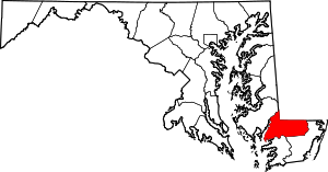
Wicomico County (/waɪˈkɒmɪkoʊ/ wy-KOM-ik-oh)[1] is a county located in the southeastern part of the U.S. state of Maryland, on the Delmarva Peninsula. As of the 2020 census, the population was 103,588.[2] The county seat is Salisbury.[3] The county was named for the Wicomico River, which in turn derives its name from the Algonquian language words wicko mekee, meaning "a place where houses are built," apparently referring to a Native American town on the banks. The county is included in the Salisbury, MD-DE Metropolitan Statistical Area. The county is part of the Lower Eastern Shore region of the state.
- ^ Weiner, Tim. "Ex-Director of C.I.A. Disappears While Canoeing on Choppy River", The New York Times, April 30, 1996. Retrieved on April 25, 2009.
- ^ "Explore Census Data". data.census.gov. Retrieved August 13, 2022.
- ^ "Find a County". National Association of Counties. Retrieved June 7, 2011.

