| Wildcat Creek Arroyo Seco, Arroyo Chiquito | |
|---|---|
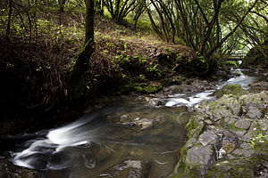
 Wildcat Creek in 2011 | |
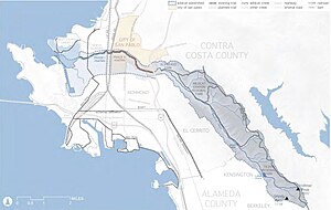
 Map of the Wildcat Creek watershed | |
| Location | |
| Country | United States |
| State | California |
| Region | Contra Costa County |
| Cities | San Pablo, Richmond |
| Physical characteristics | |
| Source | Vollmer Peak, Berkeley Hills |
| • location | Tilden Regional Park |
| • coordinates | 37°52′55″N 122°13′34″W / 37.88194°N 122.22611°W[1] |
| • elevation | 1,515 ft (462 m) |
| Mouth | Castro Creek |
• location | Richmond, California |
• coordinates | 37°57′12″N 122°23′19″W / 37.95333°N 122.38861°W[1] |
• elevation | 16 ft (4.9 m)[1] |
| Length | 12.5 mi (20.1 km) |
| Basin features | |
| Tributaries | |
| • right | Laurel Creek, Havey Creek |
Wildcat Creek is a 13.4-mile-long (21.6 km)[2][3] creek which flows through Wildcat Canyon situated between the Berkeley Hills and the San Pablo Ridge, emptying into San Pablo Bay in Contra Costa County, northern California.
- ^ a b c U.S. Geological Survey Geographic Names Information System: Wildcat Creek
- ^ Cite error: The named reference
Planwas invoked but never defined (see the help page). - ^ U.S. Geological Survey. National Hydrography Dataset high-resolution flowline data. The National Map, accessed March 15, 2011