Wildwood, Missouri | |
|---|---|
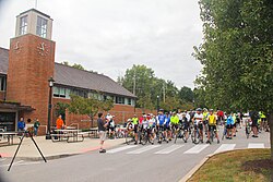
 Bicycle event at Wildwood Municipal Building, October 2016 | |
| Motto: “Planning Tomorrow Today” | |
 Location of Wildwood, Missouri | |
| Coordinates: 38°34′48″N 90°40′11″W / 38.58000°N 90.66972°W | |
| Country | United States |
| State | Missouri |
| County | St. Louis |
| Government | |
| • Mayor | Joe Garritano |
| Area | |
• Total | 66.89 sq mi (173.25 km2) |
| • Land | 66.68 sq mi (172.70 km2) |
| • Water | 0.21 sq mi (0.55 km2) |
| Elevation | 764 ft (233 m) |
| Population (2020) | |
• Total | 35,417 |
| • Density | 531.14/sq mi (205.07/km2) |
| Time zone | UTC−6 (Central (CST)) |
| • Summer (DST) | UTC−5 (CDT) |
| FIPS code | 29-79820[3] |
| GNIS feature ID | 2397311[2] |
| Website | www.cityofwildwood.com |
Wildwood is a city in St. Louis County, Missouri, United States. It is located in the far western portion of the county. As of the 2020 census, the population was 35,417.[4] Wildwood is the home of the Al Foster Trail,[5] and numerous other trails, parks, and reserves such as Rockwoods Reservation and Babler State Park.
- ^ "ArcGIS REST Services Directory". United States Census Bureau. Retrieved August 28, 2022.
- ^ a b U.S. Geological Survey Geographic Names Information System: Wildwood, Missouri
- ^ "U.S. Census website". United States Census Bureau. Retrieved January 31, 2008.
- ^ "United States Census Bureau". Retrieved February 6, 2022.
- ^ "Al Foster Memorial Trail | Wildwood, MO - Official Website". www.cityofwildwood.com. Archived from the original on October 27, 2014.