| Willamette National Forest | |
|---|---|
 The Breitenbush River in Willamette National Forest | |
| Location | Oregon, USA |
| Nearest city | Eugene, Oregon Salem, Oregon Oakridge, Oregon |
| Coordinates | 44°6′25.56″N 122°11′4.92″W / 44.1071000°N 122.1847000°W |
| Area | 1,678,031 acres (6,790.75 km2)[1] |
| Established | July 1, 1933[2] |
| Visitors | 1,740,000 (in 2006)[3] |
| Governing body | United States Forest Service |
| Website | Willamette National Forest |

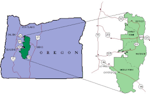
The Willamette National Forest is a National Forest located in the central portion of the Cascade Range of the U.S. state of Oregon.[4] It comprises 1,678,031 acres (6,790.75 km2). Over 380,000 acres (694 mi2, 1,540 km2) are designated wilderness which include seven major mountain peaks. There are also several National Wild and Scenic Rivers within the forest. The forest is named for the Willamette River, which has its headwaters in the forest. The forest's headquarters are located in the city of Springfield.[5] There are local ranger district offices in McKenzie Bridge, Detroit, Sweet Home, and Westfir.[6]
The forest stretches for over 100 miles (160 km) along the western slopes of the Cascades in Western Oregon. It extends from the Mount Jefferson area east of Salem to the Calapooya Ridge which divides the watersheds of the Willamette and Umpqua rivers. About 61% of the forest is located in Lane County, but there are large areas in Linn, Marion, and Douglas counties, as well as much smaller areas in Clackamas and Jefferson counties.
- ^ "Land Areas of the National Forest System" (PDF). U.S. Forest Service. January 2012. Retrieved June 30, 2012.
- ^ "The National Forests of the United States" (PDF). Forest History Society. Retrieved July 30, 2012.
- ^ Revised Visitation Estimates (PDF)- National Forest Service
- ^ "National Forests of Oregon and Washington". Retrieved December 28, 2006.
- ^ "Willamette National Forest". Retrieved July 19, 2017.
- ^ USFS Ranger Districts by State
