| Williamson River | |
|---|---|
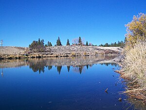
 Upstream view within the Williamson River Indian Mission in Chiloquin | |
 The Williamson, Sprague, and Klamath rivers | |
| Etymology | Robert S. Williamson, who conducted Pacific Railroad Surveys in central Oregon[2] |
| Location | |
| Country | United States |
| State | Oregon |
| County | Klamath |
| Physical characteristics | |
| Source | near Bottle Spring |
| • location | Winema National Forest |
| • coordinates | 42°42′15″N 121°20′24″W / 42.70417°N 121.34000°W[1] |
| • elevation | 5,100 ft (1,600 m)[3] |
| Mouth | Upper Klamath Lake |
• location | near Modoc Point |
• coordinates | 42°27′53″N 121°57′25″W / 42.46472°N 121.95694°W[1] |
• elevation | 4,147 ft (1,264 m)[1] |
| Length | 100 mi (160 km)[4] |
| Basin size | 3,000 sq mi (7,800 km2)[5] |
| Discharge | |
| • location | near Chiloquin, 10.3 miles (16.6 km) from the mouth[6] |
| • average | 1,032 cu ft/s (29.2 m3/s)[7] |
| • minimum | 285 cu ft/s (8.1 m3/s) |
| • maximum | 17,100 cu ft/s (480 m3/s) |
The Williamson River of south-central Oregon in the United States is about 100 miles (160 km) long.[8] It drains about 3,000 square miles (7,800 km2) east of the Cascade Range.[5] Together with its principal tributary, the Sprague River, it provides over half the inflow to Upper Klamath Lake,[5] the largest freshwater lake in Oregon.[9] The lake's outlet is the Link River, which flows into Lake Ewauna and the Klamath River.[9]
- ^ a b c "Williamson River". Geographic Names Information System. United States Geological Survey (USGS). November 28, 1980. Retrieved August 16, 2010.
- ^ McArthur, Lewis A.; Lewis L. McArthur (2003) [1928]. Oregon Geographic Names (7th ed.). Portland: Oregon Historical Society Press. pp. 1043–44. ISBN 0-87595-277-1.
- ^ Source elevation derived from Google Earth search using GNIS source coordinates.
- ^ Cite error: The named reference
Sheehanwas invoked but never defined (see the help page). - ^ a b c Risley, John C.; Laenen, Antonius (1999). "Upper Klamath Lake Basin Nutrient-Loading Study—Assessment of Historic flows in the Williamson and Sprague Rivers" (PDF). United States Geological Survey (USGS). p. 2. Retrieved March 4, 2011.
- ^ "Water-Date Report 2009: 11502500 Williamson River below Sprague River, near Chiloquin, OR" (PDF). United States Geological Survey. Retrieved March 4, 2011.
- ^ "Water-Date Report 2009: 11502500 Williamson River below Sprague River, near Chiloquin, OR" (PDF). United States Geological Survey. Retrieved March 4, 2011.
- ^ U.S. Geological Survey. National Hydrography Dataset high-resolution flowline data. The National Map, accessed March 9, 2011
- ^ a b Johnson, Daniel M.; et al. (1985). Atlas of Oregon Lakes. Corvallis: Oregon State University Press. pp. 136–37. ISBN 0-87071-343-4.
