| Willimantic River | |
|---|---|
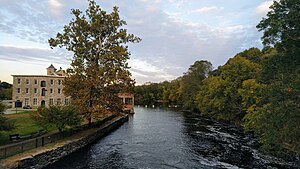
 The Willimantic River flows past the old American Thread Company mill in Willimantic. | |
 | |
| Location | |
| Country | United States |
| State | Connecticut |
| Counties | Tolland, Windham, New London |
| Physical characteristics | |
| Source | Confluence of Middle River and Furnace Brook |
| • location | Stafford Springs, Tolland County, Connecticut, United States |
| • coordinates | 41°57′09″N 72°18′07″W / 41.95250°N 72.30194°W[1] |
| Mouth | Confluence with Natchaug River to form Shetucket River |
• location | Willimantic, Windham County, Connecticut, United States |
• coordinates | 41°42′46″N 72°11′30″W / 41.71278°N 72.19167°W[2] |
| Length | 25 mi (40 km) |
| Basin size | 225 sq mi (580 km2) |
| Discharge | |
| • location | Coventry, CT |
| • average | 216 cu ft/s (6.1 m3/s)Average, 1931-2005 |
| • minimum | 97.9 cu ft/s (2.77 m3/s)Annual mean, 1965 |
| • maximum | 370 cu ft/s (10 m3/s)Annual mean, 1938 |
The Willimantic River is a tributary of the Shetucket River, approximately 25 miles (40 km) long in northeastern Connecticut in the New England region of the United States.
It is formed in northern Tolland County, near Stafford Springs by the confluence of Middle River and Furnace Brook. It flows south to the city of Willimantic, where it joins the Natchaug River to form the Shetucket. It is joined by the Hop River on the Coventry, Columbia, and Windham town border.[3] The river is also designated as a National Recreation Trail.[4]
- ^ Geographic Names Information System, United States Geological Survey (September 12, 1979). "Geographic Names Information System Feature Detail Report: Willimantic River". Retrieved 2007-06-04.
- ^ Geographic Names Information System, United States Geological Survey (September 12, 1979). "Geographic Names Information System Feature Detail Report: Natchaug River". Retrieved 2007-06-04.
- ^ "Meet the Willimantic River Watershed". www.willimanticriver.org. Retrieved 2017-03-04.
- ^ "Willimantic River Water Trail". NRT Database. Retrieved August 20, 2024.