Wilson, Wyoming | |
|---|---|
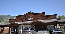
 Wilson, Wyoming Post Office, August 2017 | |
| Coordinates: 43°29′11″N 110°52′45″W / 43.48639°N 110.87917°W | |
| Country | United States |
| State | Wyoming |
| County | Teton |
| Area | |
• Total | 23.44 sq mi (60.7 km2) |
| • Land | 22.96 sq mi (59.5 km2) |
| • Water | 0.48 sq mi (1.2 km2) |
| Elevation | 6,148 ft (1,874 m) |
| Population (2020) | |
• Total | 1,567 |
| • Density | 67/sq mi (26/km2) |
| Time zone | UTC-7 (Mountain (MST)) |
| • Summer (DST) | UTC-6 (MDT) |
| ZIP code | 83014 |
| Area code | 307 |
| FIPS code | 56-83765[1] |
| GNIS feature ID | 1604543[2] |
Wilson is a census-designated place (CDP) in Teton County, Wyoming, United States. The population was 1,567 at the 2020 census, up from 1,482 in 2010.[3] It is part of the Jackson, WY–ID Micropolitan Statistical Area.
Wilson was pioneered in 1889 by Elijah Nicholas Wilson, known for having lived with the Shoshone Indians as a boy in the 1850s. His book, The White Indian Boy,[4] describes his experiences, including his time as a rider for the Pony Express. The town was later named in his honor.[5] It sits at the base of Teton Pass, just northwest of Jackson on State Highway 22.
- ^ "U.S. Census website". United States Census Bureau. Retrieved January 31, 2008.
- ^ "US Board on Geographic Names". United States Geological Survey. October 25, 2007. Retrieved January 31, 2008.
- ^ "Explore Census Data". data.census.gov. Retrieved August 29, 2022.
- ^ Elijah Nicholas Wilson (1919). The White Indian Boy: The Story of Uncle Nick Among the Shoshones. World Book Company. pp. 3–. Retrieved April 4, 2013.
- ^ Elijah Nicholas Wilson (1919). The White Indian Boy: The Story of Uncle Nick Among the Shoshones. World Book Company. pp. 5–. Retrieved April 4, 2013.
