| Wilsons Promontory National Park Victoria | |
|---|---|
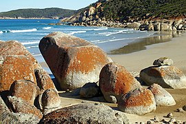
 Colourful rocks within the national park. | |
 Map of South Gippsland with the national park shown in green on lower right | |
| Nearest town or city | Yanakie |
| Coordinates | 39°00′48″S 146°23′37″E / 39.01333°S 146.39361°E |
| Established | July 1898 |
| Area | 505 km2 (195.0 sq mi)[1] |
| Managing authorities | Parks Victoria |
| Website | Wilsons Promontory National Park |
| See also | Protected areas of Victoria |
The Wilsons Promontory National Park,[2] commonly known as Wilsons Prom or The Prom,[3] is a national park in the Gippsland region of Victoria, Australia, located approximately 157 kilometres (98 mi) southeast of Melbourne.
The 50,500-hectare (125,000-acre) national park is the southernmost national park on mainland Australia, known for its rainforests, beaches and abundant wildlife. The national park covers the southern portion of Wilsons Promontory, a peninsula containing South Point, the southernmost point on the Australian mainland, and a number of islands. A lighthouse on the south-east corner of the peninsula is the southernmost lighthouse on mainland Australia and has operated continuously since 1859.
The Park is highly popular with bushwalkers and campers, and has a number of lodges and serviced camping near the mouth of Tidal River as well as a number of hike-in camping areas catering for bushwalkers.
- ^ "Wilsons Promontory National Park: Visitor Guide" (PDF). Parks Victoria (PDF). Archived from the original (PDF) on 31 March 2010. Retrieved 14 March 2010.
- ^ "Wilsons Promontory National Park". Gazetteer of Australia. Geoscience Australia. Retrieved 14 June 2009.
- ^ "Wilsons Promontory, Gippsland, Victoria, Australia". Tourism Victoria home. Retrieved 25 June 2015.
