Wilton, New Hampshire | |
|---|---|
Town | |
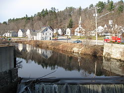
 Stony Brook near the town center | |
 Location in Hillsborough County, New Hampshire | |
| Coordinates: 42°50′36″N 71°44′06″W / 42.84333°N 71.73500°W | |
| Country | United States |
| State | New Hampshire |
| County | Hillsborough |
| Incorporated | 1762 |
| Villages |
|
| Government | |
| • Select Board |
|
| • Town Administrator | Nick Germain |
| Area | |
• Total | 25.70 sq mi (66.57 km2) |
| • Land | 25.61 sq mi (66.33 km2) |
| • Water | 0.09 sq mi (0.23 km2) 0.35% |
| Elevation | 384 ft (117 m) |
| Population (2020)[2] | |
• Total | 3,896 |
| • Density | 152/sq mi (58.7/km2) |
| Time zone | UTC-5 (Eastern) |
| • Summer (DST) | UTC-4 (Eastern) |
| ZIP code | 03086 |
| Area code | 603 |
| FIPS code | 33-85220 |
| GNIS feature ID | 0873756 |
| Website | www |
Wilton is a town in Hillsborough County, New Hampshire, United States. The population was 3,896 at the 2020 census.[2] Like many small New England towns, it grew up around water-powered textile mills, but is now a rural bedroom community with some manufacturing and service employment. Wilton is home to the High Mowing School, a private preparatory school.
The main village in town, where 1,324 people resided at the 2020 census, is defined by the U.S. Census Bureau as the Wilton census-designated place and is located near the junction of New Hampshire Routes 31 and 101, at the confluence of Stony Brook with the Souhegan River.
- ^ "2021 U.S. Gazetteer Files – New Hampshire". United States Census Bureau. Retrieved December 10, 2021.
- ^ a b "Wilton town, Hillsborough County, New Hampshire: 2020 DEC Redistricting Data (PL 94-171)". U.S. Census Bureau. Retrieved December 10, 2021.
