| Wimmera | |
|---|---|
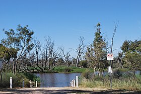
 The Wimmera River at Jeparit | |
| Native name | Walla-walla, Wamara, Bunnut, Culcatok, Barbarton, Billiwhin, Wudjum-biat, Bar, Barengi-djul, Yaigir, Wudiyedi, Barrh, Tarnorrer, Barkar, Guri-beb, Giridji-gal, Wadidirabul, Maripmunninnera[1][2][3] |
| Location | |
| Country | Australia |
| State | Victoria |
| Region | Murray Darling Depression (IBRA), Wimmera |
| Local government areas | Ararat, Northern Grampians, Yarriambiack, Horsham, Hindmarsh |
| Towns | Elmhurst, Crowlands, Glenorchy, Horsham, Dimboola, Tarranyurk, Jeparit |
| Physical characteristics | |
| Source | Pyrenees, Great Dividing Range |
| • location | below Ben Nevis, in a state forestry area south of Elmhurst |
| • coordinates | 37°16′29″S 143°15′00″E / 37.27472°S 143.25000°E |
| • elevation | 299 m (981 ft) |
| Mouth | Lake Hindmarsh, Lake Albacutya |
• location | Outlook Creek, near Jeparit |
• coordinates | 36°06′42″S 141°56′51″E / 36.11167°S 141.94750°E |
• elevation | 79 m (259 ft) |
| Length | 278 km (173 mi) |
| Basin size | 24,011 km2 (9,271 sq mi) |
| Discharge | |
| • average | 13 m3/s (460 cu ft/s) |
| Basin features | |
| River system | Wimmera catchment |
| Tributaries | |
| • left | Mount Cole Creek, Six Mile Creek (Wimmera), Seven Mile Creek (Wimmera), Concongella Creek, Sheepwash Creek, Mount William Creek, Mackenzie River, Burnt Creek, Darragan Creek, Norton Creek |
| • right | Glenpatrick Creek, Glenlofty Creek, Spring Creek (Wimmera), Heifer Station Creek |
| National parks | Wyperfeld National Park, Little Desert National Park |
| [1][4] | |
The Wimmera River, an inland intermittent river of the Wimmera catchment, is located in the Grampians and Wimmera regions of the Australian state of Victoria. Rising in the Pyrenees, on the northern slopes of the Great Dividing Range, the Wimmera River flows generally north by west and drains into Lake Hindmarsh[5] and Lake Albacutya,[5] a series of ephemeral lakes that, whilst they do not directly empty into a defined watercourse, form part of the Murray River catchment of the Murray-Darling basin.
- ^ a b "Wimmera River (entry 622167)". VICNAMES. Government of Victoria. Retrieved 23 October 2014.
- ^ Smyth, Robert Brough (1878). The Aborigines of Victoria. Melbourne: Victorian Government Printer. p. 176. OL 23539869M.
- ^ Clark, Ian; Heydon, Toby (2011). "Wimmera River: Traditional Names". Victorian Aboriginal Corporation for Languages.
- ^ "Map of Wimmera River, VIC". Bonzle Digital Atlas of Australia. Retrieved 23 October 2014.
- ^ a b Griffin, Darren; Muir, Ben. "Barringgi Gadyin – The Wimmera River and Wotjobaluk Connection to Country" (PDF). biolinksalliance.org.au. Retrieved 17 October 2021.
