| Wingfield Adelaide, South Australia | |||||||||||||||
|---|---|---|---|---|---|---|---|---|---|---|---|---|---|---|---|
| Coordinates | 34°50′31″S 138°33′50″E / 34.842°S 138.564°E | ||||||||||||||
| Population | 440 (SAL 2021)[1] | ||||||||||||||
| Established | 1877 | ||||||||||||||
| Postcode(s) | 5013 | ||||||||||||||
| LGA(s) | City of Port Adelaide Enfield | ||||||||||||||
| State electorate(s) | Electoral district of Port Adelaide | ||||||||||||||
| Federal division(s) | |||||||||||||||
| |||||||||||||||
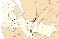
Wingfield is a suburb situated north of Adelaide. It lies between the Port River Expressway on the north and Grand Junction Road on the south. The suburb borders Dry Creek to its north and east, bounded by the Gawler railway line and Adelaide-Port Augusta railway line on the east. The North-South Motorway and Dry Creek-Port Adelaide railway line both cross the suburb. Wingfield is named after R. W. Wingfield, the private secretary to Governor of South Australia, William Jervois.[2]

- ^ Australian Bureau of Statistics (28 June 2022). "Wingfield (suburb and locality)". Australian Census 2021 QuickStats. Retrieved 28 June 2022.
- ^ "Placename Details: Wingfield". Property Location Browser. Government of South Australia. 12 May 2011. SA0061037. Retrieved 5 April 2016.
