This article needs additional citations for verification. (December 2016) |
Winseler
Wanseler (Luxembourgish) | |
|---|---|
 Winseler seen from Schëllerfeld | |
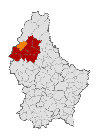
 Map of Luxembourg with Winseler highlighted in orange, and the canton in dark red | |
| Coordinates: 49°58′02″N 5°53′24″E / 49.9672°N 5.89°E | |
| Country | |
| Canton | Wiltz |
| Government | |
| • Mayor | Romain Schroeder |
| Area | |
• Total | 30.42 km2 (11.75 sq mi) |
| • Rank | 25th of 100 |
| Highest elevation | 520 m (1,710 ft) |
| • Rank | 13th of 100 |
| Lowest elevation | 320 m (1,050 ft) |
| • Rank | 99th of 100 |
| Population (2023) | |
• Total | 1,455 |
| • Rank | 90th of 100 |
| • Density | 48/km2 (120/sq mi) |
| • Rank | 97th of 100 |
| Time zone | UTC+1 (CET) |
| • Summer (DST) | UTC+2 (CEST) |
| LAU 2 | LU0000808 |
| Website | winseler.lu |
Winseler (Luxembourgish: Wanseler) is a commune and village in north-western Luxembourg.
- ^ "WINSELER - Syvicol". www.syvicol.lu. Retrieved 3 April 2019.
