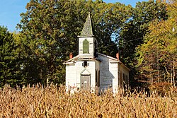
Winterham, Virginia | |
|---|---|
 Mt. Herman Presbyterian Church building, before restoration | |
| Coordinates: 37°22′4″N 77°55′53″W / 37.36778°N 77.93139°W | |
| Country | United States |
| State | Virginia |
| County | Amelia |
| Elevation | 338 ft (103 m) |
| Time zone | UTC−5 (Eastern (EST)) |
| • Summer (DST) | UTC−4 (EDT) |
| ZIP code | 23002 |
| Area code | 804 |
| GNIS feature ID | 1477890 |
Winterham (also called "Ham", according to the USGS) is a mostly rural unincorporated community in central Amelia County in the U.S. state of Virginia, lying along ![]() US 360 at the northern terminus of SR 628 (Butlers Road). Its elevation is 338 feet (103 m) above sea level.[1] Winterham is served by the volunteer fire department and post office at the county seat, Amelia Court House (ZIP code 23002), approximately 3 miles southwest.[2]
US 360 at the northern terminus of SR 628 (Butlers Road). Its elevation is 338 feet (103 m) above sea level.[1] Winterham is served by the volunteer fire department and post office at the county seat, Amelia Court House (ZIP code 23002), approximately 3 miles southwest.[2]
- ^ U.S. Geological Survey Geographic Names Information System: Winterham, Virginia, 1979-09-28. Accessed 2008-06-06.
- ^ The Road Atlas '08. Chicago: Rand McNally, 2008, p. 107.

