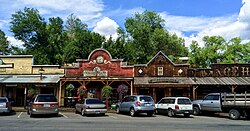
Winthrop, Washington | |
|---|---|
 Downtown Winthrop | |
 Location of Winthrop, Washington | |
| Coordinates: 48°28′25″N 120°10′44″W / 48.47361°N 120.17889°W | |
| Country | United States |
| State | Washington |
| County | Okanogan |
| Area | |
| • Total | 0.93 sq mi (2.42 km2) |
| • Land | 0.93 sq mi (2.42 km2) |
| • Water | 0.00 sq mi (0.00 km2) |
| Elevation | 1,768 ft (539 m) |
| Population (2020) | |
| • Total | 504 |
| • Density | 540/sq mi (210/km2) |
| Time zone | UTC-8 (Pacific (PST)) |
| • Summer (DST) | UTC-7 (PDT) |
| ZIP code | 98862 |
| Area code | 509 |
| FIPS code | 53-79380 |
| GNIS feature ID | 1528259[2] |
| Website | Townofwinthrop.com |
Winthrop is a town in Okanogan County, Washington, United States. It is east of Mazama and north of Twisp. The population was 394 at the 2010 census, and increased to 504 at the 2020 census.
- ^ "2019 U.S. Gazetteer Files". United States Census Bureau. Retrieved August 7, 2020.
- ^ "Winthrop". Geographic Names Information System. United States Geological Survey, United States Department of the Interior.