| Wisconsin's 36th State Assembly district | |||||
|---|---|---|---|---|---|
2024 map defined in 2023 Wisc. Act 94 2022 map defined in Johnson v. Wisconsin Elections Commission 2011 map was defined in 2011 Wisc. Act 43 | |||||
| Assemblymember |
| ||||
| Demographics | 92.79% White 0.59% Black 1.74% Hispanic 0.58% Asian 3.54% Native American 0.13% Hawaiian/Pacific Islander | ||||
| Population (2020) • Voting age | 60,015 48,971 | ||||
| Website | Official website | ||||
| Notes | Northeast Wisconsin | ||||


The 36th Assembly district of Wisconsin is one of 99 districts in the Wisconsin State Assembly.[1] Located in northern Wisconsin, the district comprises all Florence, Forest, and Marinette counties, as well as most of the northern half of Oconto County. It includes the cities of Marinette, Crandon, Niagara, and Peshtigo, and the villages of Coleman, Crivitz, Pound, and Wausaukee. It also contains the Forest County Potawatomi Community and the Sokaogon Chippewa Community, and contains most of the Nicolet National Forest, including the Headwaters Wilderness.[2] The district is represented by Republican Jeffrey Mursau, since January 2005.[3]
The 36th Assembly district is located within Wisconsin's 12th Senate district, along with the 34th and 35th Assembly districts.[4]
-
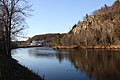 Menominee River viewed from Niagara
 -
 Headwaters Wilderness in the Nicolet National Forest
 -
-


- ^ "Assembly District 36". Wisconsin Legislature. Retrieved February 1, 2021.
- ^ "Wisconsin Legislative Districts - Assembly District 36 Boundaries". Wisconsin Legislature. Retrieved February 1, 2021.
- ^ "Representative Jeffrey Mursau". Wisconsin Legislature. Retrieved February 1, 2021.
- ^ An Act ... relating to: legislative redistricting (Act 94). Wisconsin Legislature. 2023. Retrieved February 26, 2024.