| Wisconsin's 49th State Assembly district | |||||
|---|---|---|---|---|---|
2024 map defined in 2023 Wisc. Act 94 2022 map defined in Johnson v. Wisconsin Elections Commission 2011 map was defined in 2011 Wisc. Act 43 | |||||
| Assemblymember |
| ||||
| Demographics | 93.49% White 1.87% Black 2.0% Hispanic 0.97% Asian 1.09% Native American 0.06% Hawaiian/Pacific Islander | ||||
| Population (2020) • Voting age | 59,584 47,347 | ||||
| Website | Official website | ||||
| Notes | Southwest Wisconsin | ||||


Wisconsin's 49th Assembly district is one of 99 districts in the Wisconsin State Assembly.[1] Located in southwest Wisconsin, the district comprises all of Crawford County and most of Grant County. It includes the cities of Boscobel, Fennimore, Lancaster, Platteville, and Prairie du Chien, and the villages of Bagley, Bell Center, Bloomington, Cassville, De Soto, Dickeyville, Eastman, Ferryville, Gays Mills, Lynxville, Mount Hope, Mount Sterling, Patch Grove, Potosi, Soldiers Grove, Steuben, Tennyson, Wauzeka, and Woodman. The district also contains the University of Wisconsin–Platteville campus, Wyalusing State Park, and Nelson Dewey Memorial State Park, and historic landmarks such as the Potosi Brewery and the Grant County Courthouse.[2] The district has been represented by Travis Tranel, a Republican, since January 2011.[3]
The 49th Assembly district is located within Wisconsin's 17th Senate district, along with the 50th and 51st Assembly districts.[4]
-
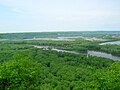
 Wyalusing Academy, in Prairie du Chien, with the Mississippi River in the background
 -
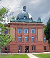 Historic Grant County Courthouse in Lancaster.
 -
 Downtown Platteville.
 -


- ^ "Assembly District 49". Wisconsin Legislature. Retrieved February 2, 2021.
- ^ "Wisconsin Legislative Districts - Assembly District 49 Boundaries". Wisconsin Legislature. Retrieved February 2, 2021.
- ^ "Representative Travis Tranel". Wisconsin Legislature. Retrieved February 2, 2021.
- ^ An Act ... relating to: legislative redistricting (Act 94). Wisconsin Legislature. 2023. Retrieved February 23, 2024.