| Wisconsin's 57th State Assembly district | |||||
|---|---|---|---|---|---|
2024 map defined in 2023 Wisc. Act 94 2022 map defined in Johnson v. Wisconsin Elections Commission 2011 map was defined in 2011 Wisc. Act 43 | |||||
| Assemblymember |
| ||||
| Demographics | 92.21% White 1.21% Black 3.62% Hispanic 0.68% Asian 1.67% Native American 0.08% Hawaiian/Pacific Islander | ||||
| Population (2020) • Voting age | 59,642 48,119 | ||||
| Website | Official website | ||||
| Notes | Central Wisconsin | ||||


The 57th Assembly District of the Wisconsin is one of 99 districts in the Wisconsin State Assembly.[1] Located in central Wisconsin, the district comprises nearly all of Waushara County and most of the southern half of Waupaca County, along with parts of western Winnebago County, southwest Outagamie County, southeast Portage County, and eastern Adams County. It includes the cities of Manawa, Wautoma, Waupaca, and Weyauwega, and the villages of Almond, Coloma, Fremont, Hancock, Lohrville, Ogdensburg, Plainfield, Redgranite, and Wild Rose. The district also contains Hartman Creek State Park and historic sites such as Waupaca's Main Street Historic District and the King Wisconsin Veterans Home, established for veterans of the American Civil War, containing the Veterans Cottages Historic District, the Commandant's Residence Home, and the Veterans Home Chapel.[2] The district is represented by Democrat Lee Snodgrass, since January 2021.[3]
The 57th Assembly District is located within Wisconsin's 19th Senate district, along with the 55th and 56th Assembly districts.[4]
-
 Downtown Wautoma
 -

-
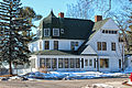 Commandant's Residence Home in the Historic Wisconsin Veterans Home
 -


- ^ "Assembly District 57". Wisconsin Legislature. Retrieved February 3, 2021.
- ^ "Wisconsin Legislative Districts - Assembly District 57 Boundaries". Wisconsin Legislature. Retrieved February 3, 2021.
- ^ "Representative Lee Snodgrass". Wisconsin Legislature. Retrieved February 3, 2021.
- ^ An Act ... relating to: legislative redistricting (Act 94). Wisconsin Legislature. 2023. Retrieved February 23, 2024.